Is Your Home in a New Flood Zone? How Climate Change Is Redrawing Risk Maps
- Matthias Herzog

- Mar 16
- 12 min read
Updated: Mar 21
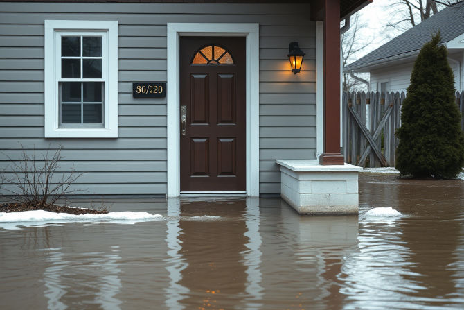
You checked the flood maps when you bought your house. You did everything right. So why is your street suddenly underwater during what used to be a "normal" rainstorm?
Here's the reality: the flood zone maps you relied on may no longer reflect current conditions. Climate change has fundamentally shifted where flooding happens, how often it occurs, and how severe it gets. Homes that were considered safe for decades are now experiencing their first floods, while previously "100-year flood" events seem to arrive every few years.
If you're a homeowner or small business owner wondering whether your property is at risk, you're asking the right question. This guide explains why flood zones have shifted so dramatically, how to determine your current risk using both official tools and on-the-ground observation, and what practical steps—including simple DIY flood protection solutions like FloodTape®—can help you protect what matters most.
Why Flood Maps No Longer Tell the Whole Story
FEMA's Flood Insurance Rate Maps (FIRMs) have long been the standard for determining flood risk. Lenders require them. Insurance companies rely on them. Homeowners trust them.
The problem? These maps are often based on historical data that no longer reflects current conditions.
According to research from the First Street Foundation—a nonprofit research organization focused on climate risk—millions of U.S. properties face substantial flood risk that isn't captured in current FEMA designations [1]. Their 2020 analysis identified approximately 6 million such properties, and subsequent research suggests this number continues to grow as climate patterns intensify. That's millions of homeowners who believe they're safe—but may not be.

The Data Lag Problem
FEMA flood maps are updated on a rolling basis, but the process can take years. Meanwhile, climate conditions change faster than bureaucratic timelines allow. A map created using rainfall data from decades past simply cannot account for the precipitation patterns we're experiencing now.
According to NOAA's Climate.gov, the contiguous United States has seen a measurable increase in heavy precipitation events since the 1950s [2]. The atmosphere now holds more moisture due to warming temperatures, which translates directly into more intense rainfall when storms occur. Your local drainage infrastructure—designed for historical rainfall patterns—may be increasingly overwhelmed.
The result is a dangerous gap between perceived risk and actual risk.
How to Read a FEMA Flood Map
When you look at a FEMA flood map, you'll see letter codes that indicate risk levels. Understanding these helps you interpret your actual exposure:
Zone Code | What It Means | Insurance Requirement |
Zone A, AE, AH, AO | High-risk areas with 1% annual chance of flooding (the "100-year floodplain") | Required if you have a federally-backed mortgage |
Zone V, VE | High-risk coastal areas subject to storm surge and wave action | Required if you have a federally-backed mortgage |
Zone X (shaded) | Moderate risk—0.2% annual chance of flooding (the "500-year floodplain") | Not required, but recommended |
Zone X (unshaded) | Minimal flood risk based on current maps | Not required |
Zone D | Undetermined risk—flood hazard not analyzed | Not required |
Here's what these designations actually mean for you: "Zone X" doesn't mean "no risk." It means lower risk based on historical data. As climate patterns shift, many Zone X properties are experiencing floods that the maps didn't predict. If your home is in Zone X but you're seeing water where you never did before, the map may simply be outdated for your specific situation.
Understanding FEMA's Risk Rating 2.0
In recent years, FEMA has been transitioning to a new methodology called Risk Rating 2.0. This updated approach calculates flood risk on a property-by-property basis rather than relying solely on broad geographic zones. It considers factors like:
Distance to water sources (rivers, lakes, coastlines)
Property elevation relative to flood sources
Flood frequency and historical claims data
Cost to rebuild the specific structure
In practical terms, this means two homes on the same street could now have different risk ratings—and different insurance premiums. Your neighbor's flood insurance bill might be very different from yours, even if you're in the same zone on paper.
While Risk Rating 2.0 represents an improvement in precision, many property owners haven't yet seen updated assessments, and the transition is ongoing. Don't wait for official reclassification to assess your own risk.
How Climate Change Intensifies Flooding
Several climate-driven factors are expanding flood zones beyond their historical boundaries:
Heavier rainfall events. Warmer air holds more moisture—about 7% more for every degree Celsius of warming, according to atmospheric science principles [2]. When that moisture releases, it dumps more water in shorter periods. What your local drainage system was designed to handle twenty years ago may be insufficient for today's storms.
Rising sea levels. Coastal communities face compounding risks as higher baseline water levels mean storm surges push further inland than ever before. NOAA data shows sea levels along U.S. coastlines have risen measurably over the past several decades, with the rate of rise accelerating [3].
Rapid snowmelt. In northern regions, warmer winters lead to faster spring thaws, overwhelming rivers and drainage systems that once had weeks to process gradual melt.
Urban development. More pavement means less ground absorption. Water that used to soak into soil now rushes toward the nearest low point—which might be your property. New construction upstream or uphill from your home can redirect water flow in unexpected ways.
Signs Your Property May Be in a "New" Flood Zone
You don't need to wait for updated maps to assess your risk. Watch for these warning signs:
Standing water after moderate rain. If puddles linger in your yard or near your foundation longer than they used to, drainage patterns may have changed.
Neighbors reporting basement moisture. Groundwater levels affect entire neighborhoods. If homes near you are getting wet, yours may be next.
Visible erosion around your foundation. Water flowing where it shouldn't leaves evidence behind.
Storm drains backing up. Overwhelmed municipal systems push water back toward homes.
New construction upstream or uphill. Development changes how water moves through an area, often directing it toward established homes.
More frequent "minor" flooding. If your street floods more often than it used to—even if it's just a few inches—that's meaningful data about changing conditions.

How to Check Your Flood Risk Online
Several tools can help you understand your current flood exposure:
FEMA's Flood Map Service Center (msc.fema.gov)Enter your address and click "View Map" to see your official flood zone designation. Look for the legend to interpret zone codes. Keep in mind these may not reflect the latest Risk Rating 2.0 calculations or recent climate trends.
First Street Foundation's Flood Factor (floodfactor.com)This free tool provides property-specific risk assessments that incorporate climate projections [1]. It shows your flood risk today and how it may change over the next 30 years—information official maps don't always include.
Your state's floodplain management office often has localized data not captured in federal maps. A quick search for "[your state] floodplain management" can connect you with regional resources.
NOAA's National Weather Service provides historical precipitation data and flood event records for your area, which can help you understand local trends.
Even if these tools show low risk, trust what you observe. If water is showing up where it didn't before, that's real-world data that matters—regardless of what any map says.
The Real Cost of Waiting
Here's what catches many homeowners off guard: standard homeowner's insurance doesn't cover flood damage. Not even a little.
If you're in a federally designated high-risk flood zone with a mortgage, you're required to carry separate flood insurance through the National Flood Insurance Program (NFIP) or a private insurer. But if you're in one of those newly vulnerable areas that hasn't been officially reclassified? You probably don't have coverage—and you might not realize it until it's too late.
According to FEMA, flooding causes billions of dollars in damage across the United States each year, with individual claims routinely reaching into the tens of thousands of dollars [4]. The NFIP reports that even just one inch of floodwater in a home can cause substantial damage to floors, walls, and belongings.
And beyond the financial damage, there's the human toll:
Weeks or months displaced from your home
Irreplaceable personal items destroyed
Mold remediation that can drag on for months
The stress and uncertainty of rebuilding
Prevention isn't just cheaper than recovery. It's immeasurably less painful.
Practical Steps to Protect Your Property
The good news? You don't need to install expensive permanent flood barriers or completely regrade your property to meaningfully reduce your risk. A layered approach combining awareness, preparation, and practical tools can make a real difference.
Step 1: Know Your Vulnerabilities
Walk around your home during the next rainstorm and observe:
Where does water collect?
Which doors or windows show moisture seepage?
Are there visible gaps at the base of entry doors?
Does your garage door seal completely against the floor?
Most residential flood damage enters through predictable points: the gap under doors, around window frames, through garage door seals, and via basement windows at or below grade level.
Step 2: Address Permanent Improvements Where Feasible
Some upgrades make sense as long-term investments:
Improve grading so water flows away from your foundation
Install a sump pump if you have a basement
Clear gutters and extend downspouts at least six feet from your foundation
Consider backflow valves on floor drains to prevent sewer backup
Elevate critical utilities (HVAC, water heaters) above potential flood levels if possible
Step 3: Prepare Temporary Protection for Storm Events
Here's where homeowners often get stuck. They know a storm is coming. They want to protect their home. But sandbags are heavy, messy, and often unavailable right when you need them. Duct tape leaves sticky residue and damages paint. Professional flood barriers cost thousands and require installation.
One solution designed specifically for this gap is FloodTape®—a temporary sealing tape that can help protect entry points during flood events.
How FloodTape® Fits Into Your Flood Protection Plan
FloodTape® is an 8-inch wide, 20-foot long adhesive tape engineered specifically for temporary flood protection. Unlike improvised solutions, it's designed to seal doors, windows, garage gaps, and other entry points against water intrusion—then peel off cleanly when the threat passes.
What It Does Well
The patent-pending adhesive creates a watertight barrier when applied to clean, dry surfaces. It adheres to wood, glass, metal, stucco, vinyl, and stone, making it suitable for virtually any home exterior material [5].
Key advantages:
Leaves no residue when removed
Does not damage paint or surface finishes
Requires no tools for installation
Can be applied by one person in minutes
Works as an all-in-one solution without additional sealants or barriers
What It's Not Designed For
FloodTape® is a temporary protective measure—not a permanent solution, and not suitable for every flooding scenario. It works best for:
Low-level flooding (water seeping under doors, pooling at thresholds)
Storm preparation when you have a few hours' notice
Sealing gaps and entry points where water is likely to intrude
It's not designed for:
Deep or rapidly rising floodwater (multiple feet of water pressure)
Extended submersion over many days
Application on wet surfaces (the adhesive needs dry contact to bond properly)
Permanent installation (it's meant to be removed after the event)
For severe flooding scenarios, additional protective measures—or evacuation—may be necessary. FloodTape® is one tool in a comprehensive approach, not a magic solution.
How the Product Came to Exist
The founder of FloodTape®, Matthias Herzog, spent 15 years living in hurricane-prone St. Augustine, Florida. He tried every flood protection method available—sandbags that required backbreaking labor, duct tape that worked but destroyed his paint, silicone caulk that sealed effectively but couldn't be removed without damaging surfaces [6].
When he couldn't find a solution that was effective, affordable, and easy to remove, he invented one.
Step-by-Step Application
Using FloodTape® is straightforward:
Clean the surface. Remove dust, dirt, and moisture from the area you're sealing. The adhesive bonds best to clean, dry surfaces.
Measure and cut. Determine how much tape you need for each opening. A standard door frame typically requires 15–20 feet of tape for complete coverage.
Apply firmly. Press the tape along the gap between the door (or window) and the frame, ensuring full contact with both surfaces.
Overlap seams. Where tape sections meet, overlap by at least two inches to maintain the seal.
Seal the threshold. Don't forget the bottom of doors—this is often where water enters first.
When the storm passes and waters recede, simply peel the tape away. No scraping, no repainting, no cleanup beyond disposal.

Real-World Scenarios: When Temporary Protection Makes the Difference
To illustrate how temporary flood protection can work in practice, consider these types of situations homeowners commonly face:
Scenario 1: The Coastal Homeowner
A beachfront home in Florida weathers dozens of storms without interior water damage. Then a moderate tropical storm sends water under the front door for the first time—the result of changing storm patterns and gradually rising sea levels. The homeowner spends weeks dealing with warped hardwood floors and a significant repair bill.
For subsequent storms, having temporary door sealing ready allows the homeowner to protect entry points quickly when warnings arrive. The storm brings similar water levels to the doorstep—but nothing enters the home.
Scenario 2: The Suburban Basement
A home in a Cincinnati suburb wasn't in any designated flood zone. But after a new shopping center is built uphill from the neighborhood, moderate rains start sending water toward basement windows—runoff from new impervious surfaces that didn't exist before.
The homeowner installs permanent improvements (better grading, extended downspouts) but also keeps temporary sealing supplies on hand for significant rain events. Sealing basement windows when heavy storms are forecast prevents additional water intrusion.
Scenario 3: The Small Business
A bakery owner in Houston experiences repeat flooding that forces closure for repairs multiple times. Each closure costs significant revenue plus repair expenses.
By applying temporary seals to entry doors whenever significant storms approach, the business can reduce the risk of interior flooding. The application takes minutes. The business stays open more consistently, equipment stays dry, and customers keep coming back.
These scenarios illustrate a common pattern: temporary protection measures are most valuable when you have some warning time and your flooding risk comes primarily through entry points rather than catastrophic water levels.
Your Flood Preparedness Checklist
Use this checklist to assess and improve your readiness:
Assessment
[ ] Research your property's flood risk using FEMA maps and First Street Foundation's Flood Factor
[ ] Check NOAA historical data for precipitation trends in your area
[ ] Walk your property during rain to identify water accumulation patterns
[ ] Document vulnerable entry points (doors, windows, garage, basement)
[ ] Verify whether your homeowner's insurance covers flood damage (it likely doesn't)
[ ] Understand your current flood zone designation and what it means
Permanent Improvements
[ ] Ensure grading directs water away from foundation
[ ] Clear and extend gutters and downspouts
[ ] Install sump pump if you have a basement
[ ] Consider backflow valves on floor drains
[ ] Elevate critical utilities above potential flood levels
Emergency Supplies
[ ] Keep FloodTape® or similar temporary flood protection on hand
[ ] Store supplies where they're accessible during emergencies
[ ] Know which entry points need sealing and how much material you need
[ ] Practice applying protection before you need it in a real emergency
Documentation
[ ] Photograph your home's contents for insurance purposes
[ ] Store important documents above potential flood levels or in waterproof containers
[ ] Know your evacuation routes and have a go-bag ready
Insurance
[ ] Contact your insurance provider to discuss flood coverage options
[ ] Understand that flood insurance is available even outside designated high-risk zones
[ ] Consider that premiums are typically lower outside high-risk zones
The Bottom Line: Flood Risk Is Expanding Beyond the Maps
The maps haven't caught up to reality. Properties that were "safe" a decade ago may not be safe today. And waiting for official reclassification means waiting until after damage has already occurred.
The smart approach is proactive: understand your current risk using both official tools and your own observations, make permanent improvements where feasible, and have temporary protection ready for storm events.
FloodTape® isn't a permanent solution—it's not meant to be. It's designed for the real-world scenario most homeowners face: you have hours, not days, before water arrives, and you need something that actually works without destroying your home in the process.
Weather is unpredictable. But your response doesn't have to be.
Ready to protect your home before the next storm? Get FloodTape® now and be prepared for whatever the weather brings.
Frequently Asked Questions
How do I know if my home is in a newly at-risk flood zone?
Start with FEMA's Flood Map Service Center for your official designation, but don't stop there. First Street Foundation's Flood Factor tool incorporates climate projections that may reveal risk not captured in official maps. Most importantly, observe your property during rain events—standing water, basement moisture, or neighbor flooding are real-world indicators that matter regardless of what official maps show. If you're seeing water where you never did before, your risk profile has likely changed.
What's the difference between old flood maps and FEMA's Risk Rating 2.0?
Traditional flood maps assigned risk based on broad geographic zones—everyone in the same area got the same designation. Risk Rating 2.0 calculates risk property by property, considering factors like your specific distance to water sources, your property's elevation, and the cost to rebuild your structure. This means two neighboring homes can now have different risk ratings and different insurance premiums. The transition is ongoing, so your official designation may not yet reflect the new methodology.
Will FloodTape® damage my door frame or paint when I remove it?
No. FloodTape® is specifically engineered to leave no residue and cause no damage to painted surfaces, wood, glass, metal, or other common building materials [5]. This was a core design requirement—the founder created FloodTape® specifically because existing solutions like duct tape caused surface damage upon removal [6]. For best results, apply to clean, dry surfaces and remove within a reasonable timeframe after the flood threat has passed.
How long can FloodTape® stay applied, and how should I store unused rolls?
FloodTape® is designed for temporary use during flood events. Apply it before flooding occurs and remove it within a reasonable timeframe after waters recede. For storage, unused rolls maintain effectiveness for approximately 24 months when stored properly in a cool, dry location. Keep it somewhere accessible so you can deploy it quickly when storms approach.
Does flood insurance cover homes outside official flood zones?
Standard homeowner's insurance does not cover flood damage regardless of your location—this catches many homeowners off guard. However, separate flood insurance is available through the National Flood Insurance Program (NFIP) and private insurers even if you're outside a designated high-risk zone. In fact, premiums are typically lower for properties in moderate- or low-risk zones, making coverage more affordable. Contact your insurance provider to discuss options for your specific situation.
About This Guide
This article was developed by flood preparedness specialists with expertise in climate science and practical home protection. Our recommendations are grounded in published research from organizations including FEMA, NOAA, and the First Street Foundation, combined with real-world feedback from homeowners who have protected their properties during flood events. We believe in providing honest, actionable guidance—including acknowledging what temporary solutions can and cannot do—so you can make informed decisions about your flood risk.
Cited Works
[1] First Street Foundation — "The First National Flood Risk Assessment." https://firststreet.org/research-lab/published-research/2020-national-flood-risk-assessment-highlights/
[2] NOAA Climate.gov — "Climate Change: Global Temperature" and "Heavy Precipitation and Climate Change."
[3] NOAA — "Sea Level Rise Technical Report." https://oceanservice.noaa.gov/hazards/sealevelrise/sealevelrise-tech-report.html
[4] FEMA — "Flood Insurance."
[5] FloodTape® — "FAQs for FloodTape® | DIY Flood Protection System." https://www.myfloodtape.com/faq
[6] FloodTape® — "About FloodTape® | Waterproof Flood Protection Tape."


Comments